First Warning Forecast: Tornado Watch on the East Coast until 10 p.m
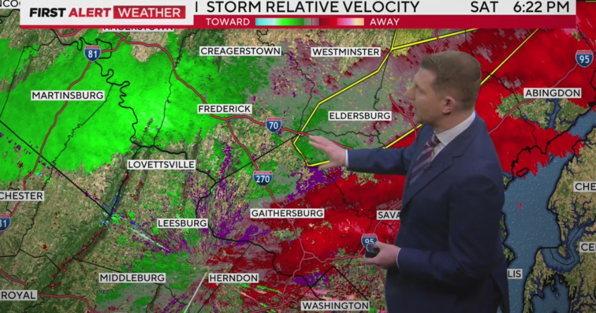
Steve Sosna has your Saturday night forecast Steve Sosna has your Saturday night forecast 03:28 Baltimore — A *SEVERE THUNDERSTORM WARNING* is in effect for Caroline, Kent and Queen Anne’s counties until 7:45 PM and a *TORNADO WATCH* has been issued for East Coast counties until 10 PM. Severe thunderstorms will be possible with a cold front. As it moves through the region this evening. Damaging winds will be the primary threat, although a few isolated tornadoes are possible mainly along the East Coast in more favorable conditions. The strongest storms are now moving south of Baltimore and I-95, and… A tornado watch is in effect for Caroline, Kent and Queen Anne’s counties until 7:45 PM and a *TORNADO WATCH* has been issued for East Coast counties until 10 PM. Severe thunderstorms are expected this evening, with gusts exceeding 50 mph in some areas. Temperatures will drop into the low 40s tonight, with the sun returning on Sunday and it will be windy again in the first half of the day. High temperatures will return to the mid-70s on Thursday, but will cool back into the high 50s Friday into next weekend. Safety tips to keep in mind during high winds include securing loose objects that can become projectiles in the wind, using generators, turning off appliances and electronics to prevent damage from power surges when power returns.
Publicado : Hace 2 años por WEBDESK en Weather
Baltimore — A *SEVERE THUNDERSTORM WARNING* is in effect for Caroline, Kent and Queen Anne’s counties until 7:45 PM and a *TORNADO WATCH* has been issued for East Coast counties until 10 PM. Severe thunderstorms will be possible with a cold front. As it moves through the region this evening. Damaging winds will be the primary threat, although a few isolated tornadoes are possible mainly along the East Coast in more favorable conditions.
Strong winds are expected across the area this evening, with gusts exceeding 50 mph in some areas. Be sure to secure any loose objects that can blow away in strong winds. A high wind warning remains in effect for much of the area late tonight. After 5pm, winds 45-55 mph will be common, with some isolated 60 mph gusts possible. A wind advisory is in effect for the East Coast until Sunday.
A cold front will move into the area this evening, with a chance of thunderstorms along the front. The best chance for these storms will be primarily east of I-95, particularly along our east coast states. There is a low threat that some storms could be strong, but there will be a greater threat north and east of Maryland.
Temperatures will drop into the low 40s tonight. The sun will return on Sunday and it will be windy again in the first half of the day. High temperatures will be in the mid to upper 50s. Expect more sun Monday with highs in the 70s and a mix of sun and clouds Tuesday with highs in the mid to upper 70s.
Rain chances will return to the region mid-week with a few scattered showers and possibly a storm or two on Wednesday. The chance of light rain will continue on Thursday and cooler weather will return later this week. High temperatures will return to the 70s on Thursday, but will cool back into the high 50s Friday into next weekend.
Here are some safety tips to keep in mind during high winds:
• Secure any loose objects that can become projectiles in the wind, such as patio furniture, trash cans, and lawn ornaments.
• Charge tablets and phones before strong winds arrive; In case of power loss.
• Trim trees and shrubs that may fall on power lines or other objects.
• If you must go outside, be aware of the potential for downed power lines and avoid them.
• If you lose power, turn off appliances and electronics to prevent damage from power surges when power returns.
• If you have a generator, use it safely and follow all manufacturer’s instructions.
Temas: Tornadoes